Madagascar rewards travelers who slow down. A route that looks straightforward on a map can involve winding mountain roads, river crossings, weather-dependent tracks, and long stretches between services. Knowing how to get around Madagascar is therefore one of the most important parts of planning a successful trip – especially if you want to combine national parks, wildlife encounters, remote landscapes, and beach time without spending every day in transit.
For most international visitors, the best approach is a carefully planned mix of private road travel, selected domestic flights, and occasional boat or local transport experiences. The right combination depends on your route, travel dates, comfort level, and how much time you have on the island.
Why transportation in Madagascar needs careful planning
Madagascar is the world’s fourth-largest island, but its transport network is not built for fast point-to-point travel. The main paved highways connect several major regions, particularly along the RN7 route from Antananarivo through the central highlands to Ranomafana, Isalo, and Tulear. Beyond those corridors, road conditions can change dramatically.
A journey of 150 miles may take five or six hours. In remote western areas, such as Tsingy de Bemaraha, the road may be slow, unpaved, and only practical in a capable 4×4. During the rainy season, roughly December through March, some tracks become difficult or temporarily impassable.
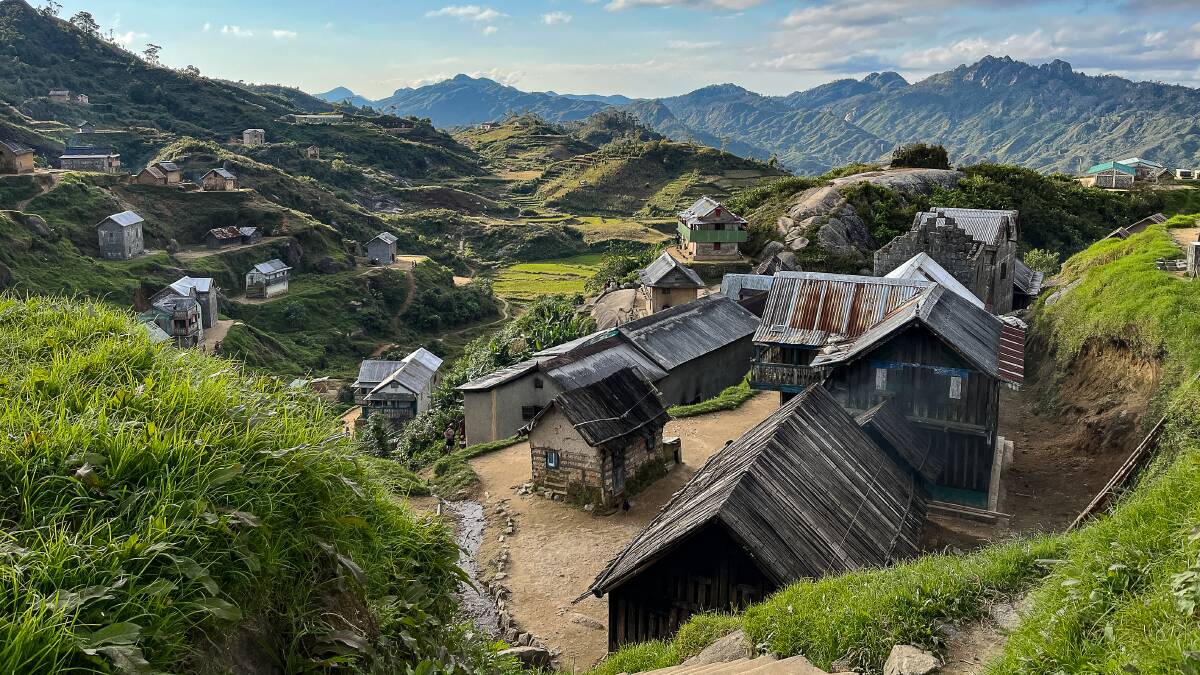
That is not a reason to avoid the country’s hidden gems. It is a reason to build an itinerary around realistic driving times, overnight stops, and the seasons. Madagascar is a destination where the journey itself often delivers the experience: rice terraces in the highlands, baobab country in the west, village markets, and ever-changing landscapes outside your window.
How to get around Madagascar: choose the right mix
There is no single best way to travel across Madagascar. Private road transport is the most flexible option for most multi-day itineraries, while flights can protect valuable time on longer routes. Boats, trains, and local shared transport add character in the right setting, but they are rarely the best foundation for a time-sensitive itinerary.
Private car and driver-guide
For a first trip or a customized circuit, traveling by private vehicle with an experienced local driver-guide is usually the most reliable choice. It allows you to stop for viewpoints, wildlife sightings, crafts, lunch, and village visits rather than being tied to a fixed timetable. It also makes it easier to adjust when weather, roadworks, or park activities affect the day’s plan.
Vehicle choice matters. A comfortable SUV or minivan is generally suitable for paved routes such as Antananarivo to Andasibe or the classic RN7 circuit. A 4×4 is essential for many western and northern adventures, including Tsingy de Bemaraha, remote sections around Morondava, and certain routes toward Ankarana.
Drivers do more than cover distance. A good local team understands where road conditions change, when to leave to avoid city traffic, where reliable rest stops are available, and how to coordinate with park guides and lodges. For travelers balancing limited vacation time with ambitious plans, that local knowledge is a major advantage.
Domestic flights
Domestic flights are useful when you want to connect distant regions without losing several days to overland travel. Flying can make it possible to pair the southern highlands with Nosy Be, or reach the north after exploring the west.
However, flights should be treated as a time-saving tool, not an inflexible guarantee. Schedules can change, routes may operate only on certain days, and delays are possible. Build buffer nights before international departures and avoid planning an important connection immediately after a domestic flight. When possible, have a road-based backup plan in mind.
Taxi-brousse and local taxis
Taxi-brousses are shared minibuses or vans used by many Malagasy people for intercity travel. They are inexpensive and culturally immersive, but they are often crowded, may leave only when full, and do not follow a dependable schedule. Luggage space can be limited, and long journeys can be physically tiring.
They can work for independent travelers with flexible schedules and a strong appetite for local travel. They are less suitable for a carefully timed wildlife itinerary, families, travelers carrying camera equipment, or anyone who values predictable comfort and support.
In cities, taxis are widely available. Agree on the fare before setting off, particularly in Antananarivo. For short urban journeys, ask your hotel or guide to arrange a trusted driver when possible.
Boats, river journeys, and trains
Some of Madagascar’s most memorable routes are on water. A multi-day descent of the Tsiribihina River can lead toward the west and Tsingy de Bemaraha, combining quiet riverbanks, camping, and local encounters. Pirogues and motorboats also provide access to coastal villages, mangroves, and parts of the Canal des Pangalanes.
These journeys require experienced local logistics. River levels, sea conditions, and departure times can shape the route, while safety equipment and boat quality vary. They are best planned as a supported experience rather than an improvised transfer.
The Fianarantsoa-Côte Est railway is another atmospheric option, traveling from the highlands toward Manakara. It is scenic and rewarding for travelers with time to spare, but delays are common and service conditions can vary. Think of it as an experience, not the fastest way to get from one place to another.
Build your itinerary around travel days
The most common planning mistake is treating Madagascar like a compact road-trip destination. A better approach is to decide which experiences matter most, then give each region the time it deserves.
A classic 15-day route can combine Antananarivo, Andasibe’s rainforest, the RN7 highlands, Ranomafana, Isalo National Park, and the southwest. A longer journey can add the Avenue of the Baobabs and Tsingy de Bemaraha, or use a domestic flight to continue north toward Ankarana and Nosy Be. Trying to include all of these places in a short visit usually means rushed park walks and exhausting transfer days.
Plan at least two nights in major wildlife areas. Andasibe deserves time for both daytime lemur tracking and night walks, while Ranomafana is far more rewarding when you have enough time for a full forest trek. In Isalo, an extra night makes room for canyons, natural pools, and a sunset viewpoint without forcing a hurried arrival or departure.
It also helps to schedule a recovery night after a difficult road section. A comfortable lodge, a beach extension, or a slower day in a highland town can transform the rhythm of a trip.
Expect different road conditions by region and season
The RN7 is the backbone of many southern circuits and is generally paved, but it still includes curves, trucks, pedestrians, livestock, and variable surfaces. Average speeds are often much lower than visitors expect. Depart early, travel during daylight, and allow time for regular breaks.
The west is more demanding. Reaching Tsingy de Bemaraha from Morondava typically involves a full day of rough-road travel and river ferries. It is an extraordinary journey, but it is not ideal for travelers who dislike long, bumpy drives. The reward is access to one of Madagascar’s most dramatic landscapes, along with the Avenue of the Baobabs and remote rural scenery.
Northern routes can also require patience, particularly outside the main towns. By contrast, beach destinations such as Nosy Be can offer a gentler finish after a demanding overland circuit. The right route is not necessarily the one that covers the most ground. It is the one that matches your appetite for adventure and leaves room to enjoy each destination.
Practical safety and comfort tips
Avoid self-driving unless you already have substantial experience with challenging international road conditions and are prepared for limited roadside support. Signage can be inconsistent, animals and pedestrians share the road, and driving after dark is not recommended.
Keep essentials accessible during long transfers: drinking water, snacks, sunscreen, insect repellent, a light rain layer, and any personal medication. Mobile coverage is uneven outside towns, so confirm daily arrangements before leaving major centers. Cash is also useful for small purchases and tips in rural areas, where card payments may not be available.
Travel insurance with medical evacuation coverage is strongly recommended, particularly for trekking, remote river trips, and areas far from major medical facilities. A reliable operator should also monitor weather, road conditions, accommodation availability, and domestic flight changes throughout the journey.
For a tailor-made trip, Travelers of Madagascar can match vehicles, drivers, guides, flights, and accommodations to your route and travel style, with local support available when plans need to change.
Give Madagascar the time it asks for
The most memorable Madagascar trips are not measured by the number of pins on a map. They are measured by a dawn call from indri lemurs, a long lunch beside the rice fields, a sunset among sandstone cliffs, or a quiet evening beneath baobabs. Choose a route with breathing room, travel with people who know the roads, and let the island’s slower pace become part of the adventure.